
Brot-Plamboz
| Kategorie: | Stadt / Gemeinde |
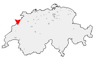
| Kanton: | Neuchâtel |
| Regierungsbezirk: | District du Locle |
| amtlicher Gemeindeschlüssel: |
G6433 |
| Einwohner: | 255 |
| Fläche: | 160,30 km² |
| Postleitzahl (PLZ): | 2318 |
|
Entfernung berechnen (zu einer anderen Stadt)

|
|