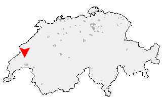
Suche
Ihre Position: Startseite - Waadt - Goumoens-le-Jux

Goumoens-le-Jux

Kategorie: Stadt / Gemeinde
Kanton: Waadt
Regierungsbezirk: District du Gros-de-Vaud
KFZ-Kennzeichen: VD
amtlicher
Gemeindeschlüssel:

G5525
Einwohner: 34
Fläche: 12,90 km²

Postleitzahl (PLZ): 1376

Entfernung berechnen (zu einer anderen Stadt)
Goumoens-le-Jux bei Wikipedia   Goumoens-le-Jux bei Google Maps


Karte von Goumoens-le-Jux

Klicken Sie auf die Karte, um nach Städten im Umkreis zu suchen.
(Sie können die Karte auch in Ihre Internet-Seite einbinden.)

Fügen Sie in den HTML-Code Ihrer Seite einfach folgenden Code ein:
<a href="https://ch.postleitzahl.org/waadt/goumoens-le-jux/" target="_blank"><img src="https://ch.postleitzahl.org/waadt/images/karte_goumoens-le-jux.png" alt="Goumoens-le-Jux"></a>


Städte im Umkreis von Goumoens-le-Jux


Premier (11.9 km) Clarmont (17.21 km)
Chavannes-le-Veyron (12.69 km) Lignerolle (13.79 km)
La Chaux (Cossonay) (11.57 km) Moiry (10.34 km)
Cottens (VD) (14.61 km) Romainmôtier-Envy (9.73 km)
Colombier (VD) (15.73 km) Grancy (12.41 km)
Vaux-sur-Morges (17.81 km) Vufflens-le-Château (18.12 km)
Bretonnières (10.33 km) Les Clées (11.41 km)
Chevilly (9.16 km) L'Abergement (13.22 km)
Monnaz (17.28 km) Vullierens (13.35 km)
Ferreyres (8.34 km) Senarclens (11.18 km)
Croy (8.13 km) Saint-Saphorin-sur-Morges (15.3 km)
Dizy (8.03 km) Echichens (17.12 km)
Bofflens (7.92 km) Sergey (11.43 km)
Cossonay (9.01 km) La Sarraz (5.99 km)
Romanel-sur-Morges (13.67 km) Agiez (8.17 km)
Aclens (12.49 km) Gollion (10.73 km)
Montcherand (9.33 km) Baulmes (14.41 km)
Arnex-sur-Orbe (5.73 km) Lonay (16.61 km)
Pompaples (5.31 km) Bremblens (14.62 km)
Lussery-Villars (6.07 km) Rances (11.96 km)
Penthalaz (7.42 km) Valeyres-sous-Rances (9.9 km)
Echandens (14.97 km) Orny (3.84 km)
Vufflens-la-Ville (10.93 km) Eclépens (3.99 km)
Penthaz (8.46 km) Mex (VD) (10.96 km)
Daillens (5.1 km) Bussigny-près-Lausanne (13.06 km)
Ecublens (VD) (15.79 km) Vuiteboeuf (15.37 km)
Orbe (6.88 km) Villars-Sainte-Croix (11.43 km)
Champvent (13.05 km) Bournens (6.71 km)
Mathod (10.39 km) Sullens (8.77 km)
Bavois (2.18 km) Chavornay (4.71 km)
Oulens-sous-Echallens (2.79 km) Bettens (4.88 km)
Chavannes-près-Renens (15.5 km) Crissier (12.35 km)
Essert-Pittet (6.67 km) Boussens (7.66 km)
Orges (15.64 km) Essert-sous-Champvent (13.81 km)
Villars-sous-Champvent (13.13 km) Saint-Barthélemy (VD) (3.98 km)
Suscévaz (10.42 km) Morrens (VD) (8.58 km)
Goumoens-le-Jux (0 km) Eclagnens (2.33 km)
Jouxtens-Mézery (12.79 km) Renens (VD) (14.67 km)
Cheseaux-sur-Lausanne (9.92 km) Chamblon (12.16 km)
Ependes (VD) (8.45 km) Suchy (5.89 km)
Valeyres-sous-Montagny (14.63 km) Corcelles-sur-Chavornay (3.95 km)
Treycovagnes (11.43 km) Etagnières (7.68 km)
Penthéréaz (1.96 km) Montagny-près-Yverdon (13.73 km)
Bioley-Orjulaz (5.59 km) Romanel-sur-Lausanne (11.94 km)
Giez (16.09 km) Goumoens-la-Ville (2.24 km)
Prilly (14.56 km) Assens (6.31 km)
Belmont-sur-Yverdon (8.36 km) Cugy (VD) (10.4 km)
Echallens (4.92 km) Gressy (9.88 km)
Yverdon-les-Bains (12.35 km) Le Mont-sur-Lausanne (13.15 km)
Bretigny-sur-Morrens (8.88 km) Villars-le-Terroir (4.37 km)
Essertines-sur-Yverdon (6.87 km) Vuarrens (4.86 km)
Valeyres-sous-Ursins (9.94 km) Bottens (7.97 km)
Lausanne (14.39 km) Poliez-le-Grand (6.76 km)
Ursins (9.66 km) Epalinges (14.33 km)
Pomy (11.69 km) Sugnens (6.8 km)
Pailly (7.75 km) Fey (7.08 km)
Orzens (9.57 km) Poliez-Pittet (9.16 km)
Belmont-sur-Lausanne (17.4 km) Cheseaux-Noréaz (15.34 km)
Froideville (10.91 km) Cuarny (14 km)
Dommartin (8.58 km) Naz (10.23 km)
Oppens (9.88 km) Villars-Epeney (15.19 km)
Cronay (12.99 km) Peyres-Possens (8.81 km)
Villars-Tiercelin (10.62 km) Bercher (9.76 km)
Montaubion-Chardonney (10.03 km) Boulens (9.79 km)
Bioley-Magnoux (11.59 km) Donneloye (13.85 km)
Ogens (11.04 km) Vernay (16.3 km)
Villars-Mendraz (11.01 km) Savigny (17.04 km)
Corcelles-le-Jorat (13.24 km) Montpreveyres (14.72 km)
Peney-le-Jorat (12.02 km)